Pacific Airfields

Ad: This forum contains affiliate links to products on Amazon and eBay. More information in Terms and rules

syscom3

Pacific Historian
14,803
10,857
Jun 4, 2005
Orange County, CA
Ive been toying with doing a thread like this for some time.

Many of the airbases in the PTO were "front line" for a matter of a few months or even weeks, before being relegated to the back area's and obscurity.

Unlike the bases in the ETO/MTO which were located near populated area's, and existed in local memory for years, many PTO bases were so isolated that when they were abandoned after the war, they were quickly forgotten by just about everyone.

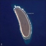
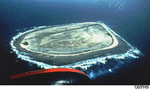
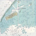
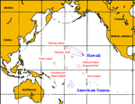
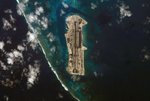
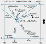
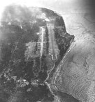
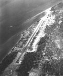
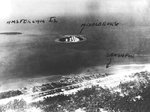
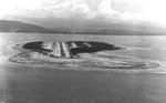
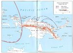
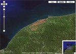
The first base I will mention here is one very very few people have ever heard of. Its located 1/2 way between Midway Island the hawaiian Islands.

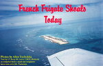
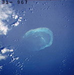
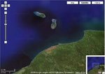
French Frigate Schoals

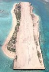
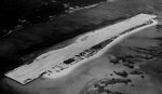
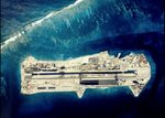
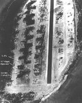
Before the war started, it was nothing but a tiny 100 yard long spit of sand, populated by sea birds. During the war, enough coral was dredged up to actually provide enough land to put down a landing strip. In 1942, the Japanese fueled up a pair of sea planes for an aborted recon/bombing of Pearl Harbor.

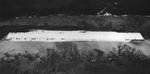
After the war, it was used by both the coast guard as a navigation (LORAN) station and then as a missle/tracking station by various military organizations.

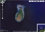
Now it is a wildlife refuge and home to multitudes of migratory birds and sea turtles.

Here are some websites that have more information. It really is a fascinating island.

http://www.letarc.net/ffsavion/
This has some great pictures of various aircraft landing on this tiny airfield.

http://www.radiojerry.com/ffstoday/
This is mostly for the island as it is today, a wildlife refuge. They have links to several pictures of the old eqmt left to rust on the island. Of interest, the tanks for the diesels that powered the LORAN eqmt, held TWO years of fuel supply.

http://radiojerry.com/frigate/
More pictures.
 

Attachments

  • tern9ab3_387.jpeg
    tern9ab3_387.jpeg
    34 KB · Views: 581
  • frenchfrigshoals_hi_60s_111.jpeg
    frenchfrigshoals_hi_60s_111.jpeg
    78.1 KB · Views: 527
  • frenchfrig_61_418.jpeg
    frenchfrig_61_418.jpeg
    38.2 KB · Views: 708
  • frenchfrigshoals_hi_43_183.jpeg
    frenchfrigshoals_hi_43_183.jpeg
    35.4 KB · Views: 499
  • nasaffs5_754.jpeg
    nasaffs5_754.jpeg
    20.7 KB · Views: 569
According to some info in the web sites listed, USN personnel were treated too three month tours of duty before being rotated back to Pearl.
 
If there ever was a catagory for worhtless islands, I would like to nominate this.

The island is located 1675 miles to the SW of Hawaii, nearly halfway to Australia.

Located in the North Pacific Ocean at (0°48′N 176°38′W), the island is tiny at just 1.84 km² (455 acres) and 6.4 km of coastline. The island has an elongated shape on a north-south axis. The climate is equatorial, with little rainfall and a burning sun. Temperatures are moderated somewhat by a constant wind from the east. The terrain is low-lying and sandy: a coral island surrounded by a narrow fringing reef with a slightly raised central area. The highest point is about 6 meters above sea level. There are no natural fresh water resources. The landscape features scattered grasses along with prostrate vines and low-growing shrubs. A 1942 eyewitness description mentioned "a low grove of dead and decaying kou trees" on a very shallow hill at the island's center but 58 years later (2000) a visitor accompanying a scientific expedition reported seeing "a flat bulldozed plain of coral sand, without a single tree" and some traces of building ruins.


WW2 history
A Japanese air attack on December 8, 1941 by fourteen twin-engined bombers killed two of the Kamehameha School colonists (Richard "Dicky" Kanani Whaley and Joseph Kealoha Keli'hananui) at the beginning of U.S. involvement in World War II. Two days later, a Japanese submarine shelled what was left of the government colony's few buildings into ruins. The two survivors were evacuated by a US Navy destroyer on January 31, 1942. The island was occupied by a battalion of United States Marines in late 1943 and known as Howland Naval Air Station during this brief period but was abandoned after the war

Kamakaiwi Field
Ground for a rudimentary aircraft landing area was cleared during the mid-1930s in anticipation that the island might eventually be used as a stop-over for a commercial trans-Pacific air route and to further U.S. territorial claims in the region. In 1937 three graded, unpaved runways were constructed by the Bureau of Air Commerce to accommodate Amelia Earhart's modern twin-engined Lockheed L-10E Electra for a scheduled refueling stop on her flight around the world. The facility was named Kamakaiwi Field after James Kamakaiwi, a young Hawaiian who arrived with the first group of four colonists. It has also been referred to as WPA Howland Airport (the WPA contributed about 20% of the $12,000 cost). The airport was never used, suffered repeated damage during World War II and later all but disappeared. Ironically, while the atoll was colonized in 1935 as a future aviation facility and is referenced in popular culture almost exclusively because of its association with the last flight of Earhart and Noonan, no airplane is known to have ever landed on Howland Island.

Here is an eyewitness account of the japanese attack.
http://kapalama.ksbe.edu/archives/historical/huipanalaau/end.php
 

Attachments

  • Howland island.jpeg
    Howland island.jpeg
    35.8 KB · Views: 447
  • howland.jpeg
    howland.jpeg
    21.9 KB · Views: 452
Here is another totally useless island who's only claim to fame was it had a servicable airfield for use during WW2. Nearby is Howland island, 40 miles away.

Located in the North Pacific Ocean at the island is tiny at just 1.64 km² (405 acres) and 4.8 km of coastline. The climate is equatorial, with little rainfall, constant wind and a burning sun. The terrain is low-lying and sandy: a coral island surrounded by a narrow fringing reef with a depressed central area. The highest point is 8 meters above sea level.

There are no natural fresh water resources. The island is treeless, with sparse vegetation consisting of grasses, prostrate vines, low growing shrubs, and some scattered ruins. A cemetery and remnants of structures from early settlement are located near the middle of the west coast. The island is primarily a nesting, roosting, and foraging habitat for seabirds, shorebirds, and marine wildlife.

There is an abandoned World War II runway, 1,665 meters long, which is completely covered with vegetation and unusable.

In 1935, a short-lived attempt at colonization was begun, as well as on nearby The settlement Meyerton had a population of four. American civilians evacuated in 1942 after Japanese air and naval attacks. During WW2 it was occupied by the U.S. military. Since the war, Baker has been uninhabited.

This island is so worthless, this is the only picture I could find of it.
 

Attachments

  • Baker Island 2.jpeg
    Baker Island 2.jpeg
    23.3 KB · Views: 575
  • baker island 1.gif
    baker island 1.gif
    40 KB · Views: 450
These indeed were the old "guano" islands that the US possesed. In the 19th century, these islands were excavated for their rich guano deposits, which had accumulated over untold millenia from the migratory birds that made them their home.

It would not be an understatment to say that these islands were "sh**holes"

At one time, the US owned 80 or so islands (the majority of them in the Carribean). All but a handfull were turned over to the various countries that they bordered on. These islands (Howland, Baker and Jarvis) were kept due to their important geographic locations in the vast central pacific.

The last island in the world that still mines guano for commercial profit is the island-state of Nauru. It to is located in the central pacific.
 
This island has a more storied history. Its WW2 history was important in that it was an important refueling base for aircraft heading towards Australia, and later in the war, towards the central Pacific.

However, it is the history of the island after the war that will be of interest to quite a few of you. But to start, for this post, here is its basic information including WW2 history.

Johnston Atoll is a 130 km² atoll in the North Pacific Ocean at 16°45′N 169°30′W, about one-third of the way from Hawai'i to the Marshall Islands. There are four islands located on the coral reef platform, two natural islands, Johnston Island and Sand Island, which have been expanded by coral dredging, as well as North Island (Akau) and East Island (Hikina), artificial islands formed from coral dredging. The four islands comprise a total land mass of 2.8 km². Due to the atoll's tilt, much of the reef on the southeast portion has subsided. But even though it does not have an encircling reef crest, the reef crest on the northwest portion of the atoll does provide for a shallow lagoon, with depths ranging from 3-10 m.

The climate is tropical but generally dry. Consistent northeast trade winds have little seasonal temperature variation. With elevation ranging from sea level to 5 m at Summit Peak, the islands contain some low-growing vegetation on mostly flat terrain and no natural fresh water resources.

WW2
Tiny Johnston Island, set off by itself in the open sea southwest of Hawaii, proved to be a favorite target of Japanese submarines in the first month of the war. It was too close to the Pacific Fleet base at Pearl and too limited in area to make it a prize worth risking an amphibious assault, but its strategic location, like an arrowhead pointing at the Japanese Marshalls, made damage to its air facilities well worth the risk of bombardment attempts. The airfield on the atoll's namesake, Johnston Island, was only partially completed on 7 December, but temporary seaplane handling facilities were in operation at Sand Islet, the only other land area within the fringing reef. There was no permanent patrol plane complement, but Johnston was an important refueling stop and a couple of PBYs were usually anchored in the lagoon.
The news of the outbreak of war created a flurry of activity on Johnston, and the civilian contractor's employees turned to at top speed to erect additional earthworks around the Marine guns and to prepare bomb shelters. No Japanese ship or submarine made its appearance on 7 December, perhaps because the first day of war found the Indianapolis and five destroyer minesweepers at Johnston testing the performance of the Higgins landing boat on coral reefs. These ships were immediately recalled toward Pearl to form part of the extensive search pattern for the enemy carrier force, and Johnston's defense rested with its own slim garrison. Major Francis B. Loomis, Jr., Executive Officer of the 1st Defense Battalion, caught while returning to Pearl by air from an inspection of the western outposts, assumed command of the Johnston detachment as senior Marine officer present.
Shortly after dark on 12 December a submarine surfaced 8,000 yards off Sand Islet and began firing green star clusters which burst high over the island. The 5-inch battery could not pick up the vessel in its sights, but it fired on star shell in the general direction of the submarine. The submarine ceased firing immediately as she evidently was not seeking a duel.
The next enemy attack came at dusk three days later. The supply ship Burrows had delivered a barge load of supplies originally intended for the Wake garrison and picked up 77 civilian construction employees for return to Pearl when a sentry atop Johnston's water tower spotted a flash to seaward and sounded general quarters. The flash had been spotted by the batteries also, and the 5-inch control estimated the range at 9,000 yards. The 3-inch director and height finder made out two ships, one larger than the other. The first two enemy salvos bracketed Johnston and the third struck near the contractor's power house and set off a 1,200-gallon oil tank which immediately fired the building. A strong wind whipped up 50-foot flames from the oil fire, and "as observed from the Naval Air Station at Sand Islet, Johnston Island seemed doomed."[22] The Japanese continued to fire for ten minutes at this well-lighted target and they hit several other buildings. The 5-inch guns delivered searching fire, and just as the Marines were convinced they were hitting close aboard their targets, the enemy fire ceased abruptly.
The enemy vessels had fired from the obscuring mists of a small squall and spotters ashore never clearly saw their targets, but the defenders believed that they had engaged two surface vessels, probably a light cruiser and a destroyer. Later analysis indicated, however, that one or more submarines had made this attack. Fortunately no one in the garrison was hurt by the enemy fire, although flames and fragments caused considerable damage to the power house and water distilling machinery. The Burrows, although clearly outlined by the fire, was not harmed. The fact that its anchorage area was known to be studded with submerged coral heads probably discouraged the Japanese from attempting an underwater attack, and Johnston's 5-inch battery ruled out a surface approach.
During the exchange of fire one of the Marines' 5-inch guns went out of action. Its counter-recoil mechanism failed. After this the long-range defense of the island rested with one gun until 18 December when two patrol bombers from Pearl arrived to join the garrison. This gun was enough, however, to scare off an enemy submarine which fired star shells over Sand Islet after dark on 21 December. Again the simple expedient of firing in the probable direction of the enemy was enough to silence the submarine. The next night, just as the ready duty PBY landed in the lagoon, another submarine, perhaps the same one that had fired illumination over Sand, fired six shells at the islets. Both 5-inchers on Johnston now were back in action and each gun fired ten rounds before the submarine submerged. The patrol plane was just lifting from the water as the last enemy shot was fired. Only one shell hit Sand, but that one knocked down the CAA homing tower and slightly wounded one Marine.
Johnston Island was clearly a discouraging place to attack, and the shelling of 22 December marked the last enemy attempt at surface bombardment. It was just as well that the Japanese decided to avoid Johnston, because reinforcement from Pearl soon had the atoll bursting at its seams with men and guns. An additional 5-inch and a 3-inch battery, 16 more machine guns, and the men to man them arrived on 30 December. In January a provisional infantry company was sent and eventually the garrison included even light tanks. The expected permanent Marine fighter complement never got settled in at Johnston's airfield. The island became instead a ferrying and refueling stop for planes going between Pearl and the South and Southwest Pacific.
 

Attachments

  • johnston_atoll_90.jpeg
    johnston_atoll_90.jpeg
    23.9 KB · Views: 445
  • map pacific 1.gif
    map pacific 1.gif
    32.8 KB · Views: 414
  • Johnston island 2.jpeg
    Johnston island 2.jpeg
    19.2 KB · Views: 435
  • johnston atoll satellite.jpeg
    johnston atoll satellite.jpeg
    97.2 KB · Views: 541
  • JA%20distances%20map_3x3.jpeg
    JA%20distances%20map_3x3.jpeg
    34.3 KB · Views: 397
Here is an account from a marine who served on the island in 1944.

I found this story, written by a marine who served on the island in 1944/1945
http://www.members.aol.com/jimmemoirs/
"Duty on Johnston" by F.E.(Jim) DeVine On Johnston, were assigned to the search radar unit which conisted of a a 200' tower and the guts or operating unit was underground. Our quarters were in a quonset hut on top of the operating unit. The unit could search the air and sea for about 150 miles. We were unfamiliar with this type of radar so the current crew had to teach us so we could relieve them for duty elsewhere. Within a couple of weeks we were competent to operate the unit. Then the Navy took over the island and brought radio men in from ships for us to teach them to maintain the unit. They soon became radarmen first class while we stayed corporals and pfcs. I remember we used to climb the 200' tower and ride around on the huge concrete counter weights for recreation. Once the Navy had the unit in hand, we were sent over to Sand Island to revive and operate the ancient 268 AA unit which was originally destined for Wake Island before it fell to the Japs. This unit was not operable when we arrived, but with a lot of work we had it ready to use with the 90mm AA battery. The war was about 1500 miles west of us so we used it mainly for tracking tow planes for practice, firing the 90's. Sand Island at the time consisted of two islands connected by a single lane, coral roadway about 600' long. The NE island was natural and about 5 acres. Here were our mess hall, theatre, boat dock, handball courts, underground ammo storage, and small barracks for an army aircorps radio navigation unit. The SW "island" was completely dredged up from the sea and was about the size of a ball diamond. It was about 18" out of high tide, and you could stand in the middle, throw a piece of coral, and hit the water. Here we had quonset huts for the officers, noncoms, and the troops; four 90mm guns and support equipment, head, slopchute,and a Navy desalting unit. Each morning we had troop and stump for an hour in fresh khakis with rifles. After that we all had to check and clean our respective equipment until lunch time. The afternoon was spent grabassing, playing handball. swimming, fishing, etc. until about 4:00 PM when the slopchute opened for beer and icecream. The most horrific instances occurred when for one whole week, we had no chocolate icecream; only vanilla and strawberry, when the icecream machine broke down. Then the movie machine broke down for a week. A shark even got into our swimming area,. This was one technological foulup after another, and how we won the war, I'll never know. To keep up the morale and from cracking up altogether, we were allowed to go on liberty to THE BIG ISLAND once a week with our loaded rifles and cartridge belts. Jim DeVine (Reading, PA)

"THE REEF" by F.E.(Jim) DeVine When I was on Sand, there were no women around so we were practically naked all the time. That's the way we swam, and the only equipment we had were the wooden carved goggles that the native Hawaiians used. We would swim out to the reef for shells, and I still have a couple of cats eyes. We used to swim out to the seaplanes and bum fesh milk and fruit from the crews. On Sunday, 2-4-45, our radar officer, Lt. Randolph H. Ogg, was swimming alone at the reef and drowned. He's buried in the Punch Bowl on Ohau. Lt. Ogg apparently died of a heart attack. He was swimming alone, and he was a straight type of guy who didn't imbibe. One Gyrene fell from the 100' tower on Sand, and 6 Seabees on Johnston died from bad moonshine they had cooked up. All deceased enlisted men were put on "channel duty" at the "outside" end of the channel which, in those days, was quite narrow and shallow. Only a small supply freighter could come thru. When someone died on the island, enlisted men only, they would be put into matress covers, weighted down, and taken to the end of the channel on the crash boat. Their bodies were then slid over the side to stand "channel duty" for eternity. END

Subject: Addendum to "Duty on Johnston" MY TWO ATTEMPTS TO ESCAPE FROM JOHNSTON/SAND ISLANDS. My first attempt to escape resulted in harsh, painful results. Whenever a low pressure weather system passed over the islands, I could not breathe and would lie in my sack gasping for air. It was suggested that I go to sick bay on Johnston for some relief. At sick bay I told the Doc that I had to get off the island because I could not breathe. He said, "No problem. Come back on Sunday afternoon and we will remove your tonsils and adenoids on Monday." I reported to sick bay on Sunday, and that evening I was given a shot in the butt to prepare me for surgery on Monday. In the morning, I was led into a room containing a sort of kitchen chair onto which I was directed to sit facing the back of the chair with my arms crossed over the back of the chair and my chin on my arms. I was still quite groggy, and two corpsmen faced me. Behind them was the Lt. Cmdr. doctor who appeared to be nursing a hangover from Sunday night's festivities. The corpsmen told me to open my mouth, and they proceeded to remove my tonsils and adenoids without further medication. It hurt like hell, and blood was spurting all over them and the room. Instead of cutting the tonsil duct, they were yanking on it. I, of course, involuntarily let out some blood-spurting howls to which they replied, "You can take this. You're a Marine". I spent 6 days in sickbay and was unable to eat any of the time because of my "damaged" throat. Because I was ambulatory, I had dishwashing kitchen duty five time a day. I became very weak and was finally rescued by my radar officer who got me back to Sand Island and told me to stay in the sack until I regained my strength . My second escape attempt happened shortly after Iwo Jima was secured, and where they had lost about 700 second lieutenants. The word was passed for volunteers for platoon leaders school to replace those lieutanants. I was one of four out of fifty guys on Sand Island who qualified for the school. At our preliminary interview with the Colonel, he asked me, "What do you do here, son?" I replied, "I'm in radar, Sir". I was dismissed along with one other radarman because radarmen could not be accepted into the program. The other two men were artillerymen, and they escaped from the island. I "accidentally" managed to escape from the island by a quirk of fate in April, 1945. I was heading for a game of handball, when I saw a bunch of guys yelling around the pier. When I got there, they said some guy had drowned. I looked around the 20 foot, clear water and saw a dark spot on the bottom. I dove in and saw the guy in a sitting position. I got him under the arms, brought him to the surface and got him to the dock where the others pulled him out and performed artificial respiration. Fortunately, he came around. His name was Cpl. Ben DuBose. I kept tabs on Ben after his infamous swim. He was transferred to Pearl, and then went to the Phillipines and later to Japan (occupation). He was in Army communications. I visited him at his home in TX in 1992. He passed away in 1995. He was attended by corpsmen and a doctor after I brought him to the surface in 1945. He spent time in the hospital in critical condition. But he survived the experience and went on to lead a full life. I have always been thankful that I was nearby when he needed me that day in Sand Island. It was simply a question of being in the right place at the right time. At the inquiry, in answer to the Colonel's question about how the situation could be improved, I suggested better boat service at Sand Island. I sensed the Colonel was unhappy with my response. Dexter Allen Nesmith and I were almost immediately transferred to casual company at Camp Catlin on Oahu. I believe that my accidental rescue of Cpl. Ben DuBose led to this transfer (which I refer to as my "successful escape from Sand Island". [see accompanying newspaper article on homepage]. In January, 1946, on my way back from Japan, I ran into my old radar crew back in Hawaii. They had just been relieved from duty on Sand Island.
END F.E. (Jim) DeVine
 

Attachments

  • johston-atol-Image2.jpeg
    johston-atol-Image2.jpeg
    72.7 KB · Views: 310
  • growth.jpeg
    growth.jpeg
    28.5 KB · Views: 274
These two airstrips were occupied in July 1944. Middleburg is an island a mile or so off shore from Sanasapor.

The attached map shows this location as being in the upper left of the map, right on the Northwest coast of the island.

Note on the attached satellite images, that even after 60 years, the airfield is still visible.

"..With the fighting along the Driniumor flickering out, MacArthur's final assault landing on New Guinea took place at Sansapor, a weak point between two known Japanese strongholds on the Vogelkop Peninsula. There were about 15,000 Japanese troops of the 35th Division at Manokwari, 120 miles east of Sansapor. Sixty miles to Sansapor's west were 12,500 enemy soldiers at the major air base complex of Sorong. Rather than fight on the enemy's terms, MacArthur employed SWPA's well-tested amphibious capability to leapfrog to Sansapor where, on 30 July, 7,300 men of the 6th Division conducted an unopposed landing. Sixth Army had once again split the Japanese forces in order to seize a coastal enclave that combat engineers quickly transformed from jungle overgrowth into two airfields that provided valuable support during MacArthur's invasion of Morotai in the Molucca chain. Japan's 35th Division found itself isolated in western New Guinea. For historical purposes, Sixth Army closed the Vogelkop operation on 31 August 1944, although the 6th Division remained there until it left for Luzon, Philippines, in January 1945. Units of the 93d Infantry Division then took over the defense of the airfields."

The capture of this island had a significant impact on the allied war effort in the SW pacific, as P38's were now in range of several important Japanese installations blocking the route to the Philipines. In addition, (I believe) the P38s were now in range of the oil refineries at Balikpapen and Tarakan.

The Pacific Wrecks website indicates the following US forces were stationed here:
HQ 18th FG, 12th FS P-38s start - January 13, 1945
18th FS, 70th FS P-38 Aug 23, 1944 - January 19, 1945 to Lingayen
18th FS, 12th FS P-38 Aug 23, 1944 - Jan 13, 45 to Lingayen
347th FG, 339th FS P-38 from Stirling August 15 - Sept 19, 1944 to Middleburg
347th FG HQ - Sept 19, 1944 to Middleburg
4th PRG, 17th PRS (F-5 det) from Guadalcanal Oct 13 - Nov 5, 1944 to Morotai
13th Fighter Command HQ from Guadalcanal Nov 13, 44 - Jan 10, 45 to Leyte
86th FW HQ from Toem August 19, 1944 - Jan 16, 45 to Luzon
18th FG, 12th FS P-38 August 23, 1944
42nd BG, 75th BS (B-25) from Hollanida Sept 14, 44 - Feb 23, 45 to Morotai
42nd BG, 100th BS (B-25) from Hollanida Sept 14, 44 - Mar 15, 45 to Palawan
42nd BG, 69th BS (B-25) from Hollandia Sept 14, 44 - Mar 12, 45 to Puerto Princesa
42nd BG HQ from Hollandia Sept 16, 44 - Feb 22, 45 to Morotai
42nd BG, 75th BS from Hollandia Sept 20, 44 - March 22, 45 to Puerto Princesa
42nd BG, 390th BS ? - Feb 24, 45 to Morotai

The RAAF had units here, and I will list them later.
 

Attachments

  • 2ERS00646.jpg
    2ERS00646.jpg
    141 KB · Views: 252
  • 2ERS00644.jpg
    2ERS00644.jpg
    125.8 KB · Views: 381
  • 2ERS00637.jpg
    2ERS00637.jpg
    92.5 KB · Views: 242
  • 2ERS00634.jpg
    2ERS00634.jpg
    64.6 KB · Views: 334
  • map3.jpg
    map3.jpg
    160.9 KB · Views: 248
  • 2ERS00648.jpg
    2ERS00648.jpg
    149.2 KB · Views: 540
  • Middleburg and sanaspore.JPG
    Middleburg and sanaspore.JPG
    41.9 KB · Views: 252
  • middleburg.JPG
    middleburg.JPG
    28.6 KB · Views: 266
  • sansapore.JPG
    sansapore.JPG
    54.4 KB · Views: 306
Good interesting thread here syscom!

That first one that you talked about was still in use about 5 years ago by the Navy. Granted there were only a small handful of people stationed there for observatory reasons but they are all gone now.
 

Users who are viewing this thread

Back