BikerBabe
Senior Master Sergeant
...you can always track down WW2-related places in Google Earth and Google Maps.
A few years ago, I stumbled upon a french website, Anciens Aérodromes - in english: Former Airfields, owned and maintained by a small group of people with an interest in WW2 history - among them is a guy named Nicolas Grebert.
Monsieur Grebert have visited Audembert, home of (among others) JG 26, during WW2.
Audembert | Anciens Aérodromes
Using Grebert's map of that area, I started Google Earth and Google Maps, and made some screencaps:
First, Grebert's map from the homepage:

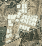
A screen cap from Google Earth:

Some 109 shelter remains are still visible in Audembert. Image from the Anciens Aérodrome website:

Viewed with Google Street View:


The 109 shelters can be found where the red circle is on this GE overview:

The yellow circle shows the old taxiway, and the blue circle is the JG 26 HQ - Le Hameau du Colombier, where some familiar photos were once shot - images from the website:
First, the JG 26 HQ - it's the lower white building in the aerial photo from the website.
If you look to the slightly lower left in the photo, you'll see some old 109 hangars/shelters in the garden of Le Hameau du Colombier:

Same area in GE - top blue square is the building with surrounding area (the tiny brighter square by the building is the terrace) - lower blue square shows 109 shelters:

Next, a couple of pilots relax on the terrace of the HQ.")

The terrace a few years ago - the old wall and tiles are still there:

Then - Galland and his hunting dog "Schweinebauch" relaxes on the terrace:

Now - same corner, same tiles and wall again:

Galland and Mölders - together with a third unknown person:

The building is almost the same as back then:

The old taxiway - yellow circle on the overview GE screencap - from the homepage:

Taxiway - GE screencap - yellow square shows another 109 shelter:

So...if you've got nothing else planned for your christmas holiday, I'll suggest that you go treasure hunting with Google Earth and Google Street View.
You can always start on the abovementioned website, there's plenty of places to explore.
And if you're curious, here's the GE file for JG 26 - Audembert:
http://www.bmwmc.dk/2011/JG_26_Audembert.kmz
A few years ago, I stumbled upon a french website, Anciens Aérodromes - in english: Former Airfields, owned and maintained by a small group of people with an interest in WW2 history - among them is a guy named Nicolas Grebert.
Monsieur Grebert have visited Audembert, home of (among others) JG 26, during WW2.
Audembert | Anciens Aérodromes
Using Grebert's map of that area, I started Google Earth and Google Maps, and made some screencaps:
First, Grebert's map from the homepage:
A screen cap from Google Earth:
Some 109 shelter remains are still visible in Audembert. Image from the Anciens Aérodrome website:
Viewed with Google Street View:
The 109 shelters can be found where the red circle is on this GE overview:
The yellow circle shows the old taxiway, and the blue circle is the JG 26 HQ - Le Hameau du Colombier, where some familiar photos were once shot - images from the website:
First, the JG 26 HQ - it's the lower white building in the aerial photo from the website.
If you look to the slightly lower left in the photo, you'll see some old 109 hangars/shelters in the garden of Le Hameau du Colombier:
Same area in GE - top blue square is the building with surrounding area (the tiny brighter square by the building is the terrace) - lower blue square shows 109 shelters:
Next, a couple of pilots relax on the terrace of the HQ.
The terrace a few years ago - the old wall and tiles are still there:
Then - Galland and his hunting dog "Schweinebauch" relaxes on the terrace:
Now - same corner, same tiles and wall again:
Galland and Mölders - together with a third unknown person:
The building is almost the same as back then:
The old taxiway - yellow circle on the overview GE screencap - from the homepage:
Taxiway - GE screencap - yellow square shows another 109 shelter:
So...if you've got nothing else planned for your christmas holiday, I'll suggest that you go treasure hunting with Google Earth and Google Street View.
You can always start on the abovementioned website, there's plenty of places to explore.
And if you're curious, here's the GE file for JG 26 - Audembert:
http://www.bmwmc.dk/2011/JG_26_Audembert.kmz
Last edited: